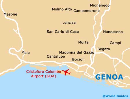
Genoa Cristoforo Colombo Airport (GOA)
Orientation and Maps
(Genoa, Italy)
The capital of the Liguria area in north-western Italy, Genoa (Genova) is particularly close to the French border, with Cannes, Monaco and Nice all being within driving distance. Also nearby, Genoa is directly south of Milan (Milano), which is situated approximately 145 km / 90 miles to the north, being less than a two-hour drive.
Served by Genoa Cristoforo Colombo Airport (GOA) to the east of the city, Genoa has grown rapidly over recent years and is now home to a population of almost 700,000 inhabitants, making it the fifth-biggest city in the whole of Italy, also containing the country's largest seaport.
Genoa Cristoforo Colombo Airport (GOA) Maps: Important City Districts
The city of Genoa is full of winding streets and medieval alleys, with many palatial buildings squeezed in around public squares, such as the Palazzo Ducale at the Piazza Matteotti. Spreading outwards from the vast port, the historic Old Town area is situated close to the waterfront and is edged by the Via Gramsci.
Two main train stations can be found in Genoa. The Stazione Principe is situated at the Piazza Acquaverde, on the northern side of the port, while the Stazione Brignole can be found at the Piazza Verdi, on the eastern side of Genoa city centre.
On the western side of the Piazza Matteotti you will find Genoa's breathtaking Cattedrale di San Lorenzo, which dominates the area. The neighbourhood surrounding the cathedral is a particularly vibrant part of Genoa, being full of many cultural attractions, such as art galleries and fashion stores, off the Via San Lorenzo.
Italy Map

Genoa Map